[{"id":160211992676,"handle":"all-products","title":"All Products","updated_at":"2025-03-13T12:25:02+00:00","body_html":"","published_at":"2020-05-12T10:33:34+01:00","sort_order":"manual","template_suffix":"","disjunctive":true,"rules":[{"column":"tag","relation":"equals","condition":"Cornwall and Scilly guidebooks"},{"column":"tag","relation":"equals","condition":"Maps and Pocket Guides"}],"published_scope":"web","image":{"created_at":"2023-04-14T16:46:57+01:00","alt":null,"width":4000,"height":2630,"src":"\/\/www.friendly-guides.uk\/cdn\/shop\/collections\/godrevy-gwithian-baech-st-ives-cornwall-friendly-guides.jpg?v=1681487217"}},{"id":29948295,"handle":"isles-of-scilly","updated_at":"2025-03-13T12:25:02+00:00","published_at":"2014-10-26T09:40:00+00:00","sort_order":"manual","template_suffix":"","published_scope":"web","title":"Isles of Scilly","body_html":"If you’re visiting Scilly for the first time, we recommend trying our \u003cstrong\u003eIsles of Scilly Guidebook\u003c\/strong\u003e and \u003cstrong\u003eIsles of Scilly Map\u003c\/strong\u003e as they give a good overview of the whole group. Each inhabited island is also covered by a superscale (1:10,000) \u003cstrong\u003eScilly Pocket Map\u003c\/strong\u003e and a \u003cstrong\u003eScilly Island by Island\u003c\/strong\u003e book – they are packed with photos, detailed descriptions and walks. Both can be purchased as \u003cstrong\u003ecollections\u003c\/strong\u003e.","image":{"created_at":"2023-03-22T18:49:07+00:00","alt":"A couple sit on the beach looking over Great Par","width":3840,"height":2160,"src":"\/\/www.friendly-guides.uk\/cdn\/shop\/collections\/isles-of-scilly-381296.jpg?v=1681486658"}},{"id":30188059,"handle":"maps-and-pocket-guides","updated_at":"2025-03-13T12:25:02+00:00","published_at":"2020-04-01T18:09:00+01:00","sort_order":"manual","template_suffix":"","published_scope":"web","title":"Maps and Pocket Guides","body_html":"\u003cp\u003e\u003cspan style=\"color: #000000;\"\u003eOur Pocket Guides are a combination of map and guide. Superscale maps show local footpaths, cafes, pubs, loos, ancient sites, nature trails and ferry landing places. They tell you the best places and beaches to visit, plus the best local walks. So whether you live locally or are planning a visit, we will help you get the most fun and interest out of exploring an area.\u003c\/span\u003e\u003c\/p\u003e","image":{"created_at":"2023-03-22T18:49:11+00:00","alt":"Maps and Pocket Guides - Friendly Guides","width":3846,"height":1850,"src":"\/\/www.friendly-guides.uk\/cdn\/shop\/collections\/maps-and-pocket-guides-109303.jpg?v=1679510951"}}]
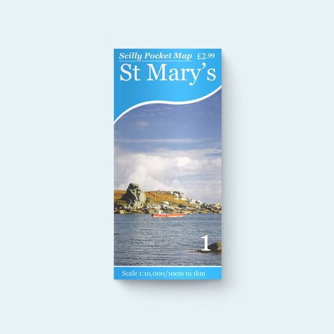
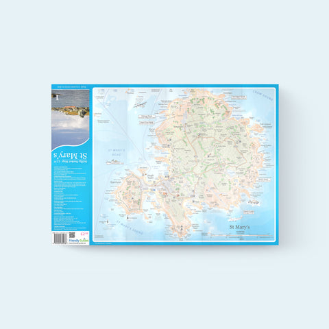
The most detailed map of St Mary's available covering the whole island from the Garrison and Star Castle to Peninnis, Porth Hellick, Holy Vale and Porthloo. Perfect for day trips on the Scillonian, Skybus and helicopter. Shows all the best walks, places to visit, loos and cafes.
This guide is ideal as I've never been to the Scilly Isles before. It shows all the places of interest and it will really help me see the best if the isle
C
Catherine
Excellent
Really good map - very clear and detailed. Excellent choice if you are planning on walking or cycling around the island.
K
Kindle Customer (Amazon review)
Perfect
Just what I wanted. Easy navigating the island with this map.