[{"id":160211992676,"handle":"all-products","title":"All Products","updated_at":"2025-04-22T20:40:10+01:00","body_html":"","published_at":"2020-05-12T10:33:34+01:00","sort_order":"manual","template_suffix":"","disjunctive":true,"rules":[{"column":"tag","relation":"equals","condition":"Cornwall and Scilly guidebooks"},{"column":"tag","relation":"equals","condition":"Maps and Pocket Guides"}],"published_scope":"web","image":{"created_at":"2023-04-14T16:46:57+01:00","alt":null,"width":4000,"height":2630,"src":"\/\/www.friendly-guides.uk\/cdn\/shop\/collections\/godrevy-gwithian-baech-st-ives-cornwall-friendly-guides.jpg?v=1681487217"}},{"id":29948295,"handle":"isles-of-scilly","updated_at":"2025-04-22T20:40:10+01:00","published_at":"2014-10-26T09:40:00+00:00","sort_order":"manual","template_suffix":"","published_scope":"web","title":"Isles of Scilly","body_html":"If you’re visiting Scilly for the first time, we recommend trying our \u003cstrong\u003eIsles of Scilly Guidebook\u003c\/strong\u003e and \u003cstrong\u003eIsles of Scilly Map\u003c\/strong\u003e as they give a good overview of the whole group. Each inhabited island is also covered by a superscale (1:10,000) \u003cstrong\u003eScilly Pocket Map\u003c\/strong\u003e and a \u003cstrong\u003eScilly Island by Island\u003c\/strong\u003e book – they are packed with photos, detailed descriptions and walks. Both can be purchased as \u003cstrong\u003ecollections\u003c\/strong\u003e.","image":{"created_at":"2023-03-22T18:49:07+00:00","alt":"A couple sit on the beach looking over Great Par","width":3840,"height":2160,"src":"\/\/www.friendly-guides.uk\/cdn\/shop\/collections\/isles-of-scilly-381296.jpg?v=1681486658"}},{"id":30188059,"handle":"maps-and-pocket-guides","updated_at":"2025-04-22T18:55:36+01:00","published_at":"2020-04-01T18:09:00+01:00","sort_order":"manual","template_suffix":"","published_scope":"web","title":"Maps and Pocket Guides","body_html":"\u003cp\u003e\u003cspan style=\"color: #000000;\"\u003eOur Pocket Guides are a combination of map and guide. Superscale maps show local footpaths, cafes, pubs, loos, ancient sites, nature trails and ferry landing places. They tell you the best places and beaches to visit, plus the best local walks. So whether you live locally or are planning a visit, we will help you get the most fun and interest out of exploring an area.\u003c\/span\u003e\u003c\/p\u003e","image":{"created_at":"2023-03-22T18:49:11+00:00","alt":"Maps and Pocket Guides - Friendly Guides","width":3846,"height":1850,"src":"\/\/www.friendly-guides.uk\/cdn\/shop\/collections\/maps-and-pocket-guides-109303.jpg?v=1679510951"}}]
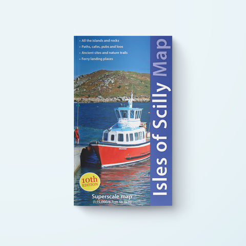
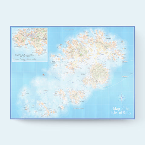
This highly detailed map shows every rock, island, cove and corner of Scilly from Lion Rock to the Bishop Rock Lighthouse and from Hanjague to the Maiden Bower. A good option for those wanting an overview of the whole island group.
Essential companion for any visit to Scilly. Comprehensive and easy to read.
P
Philip Looker
IoS Detailed Map
Using the same excellent detailed maps from the IoS Guidebook (Friendly Guides) this brings all the sectioned maps into one view.
I would recommend buying this together with the Excellent Guidebook
C
Carol Peacock
Excellent service
Would definitely recommend friendly Guides. Neil was very quick at responding to my emails and went above and beyond to ensure i received my map promptly. Would not hesitate in using him again.
P
PETER WELSH
First class for clarity and info.
L
Louisa Holbrook
Great map produced by locals
I bought this map to replace another from the same publisher, which had worn out. I like the updates which now include Old Town in the larger inset with Hugh Town, and the Western Isles part of the main map. Consequently the map is larger than my original copy. Having not visited the Isles for 4 years and planning a trip this September, it’s great to have a fully updated map as my guide!